 View notices
Glacier collapse triggers flash flood on Nepal-China border
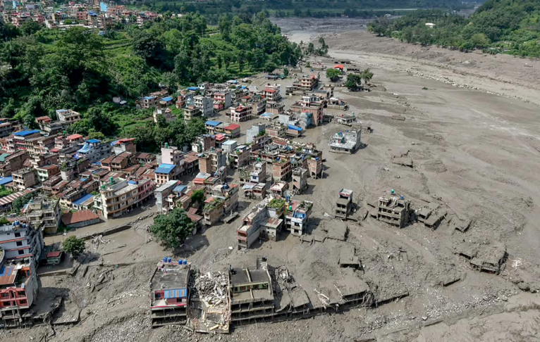
A catastrophic flash flood swept through Himalayan border communities in Nepal and Tibet on Wednesday after a glacier collapsed high in the mountains, leaving hundreds of people dead and more than 1,300 others missing.
According to the US Geological Survey (USGS), a large section of glacier broke off at an altitude of around 5,200 metres and plunged approximately a kilometre down the mountainside onto the valley floor below at 8:37am local time.
The event was initially registered by seismometers as an earthquake measuring between magnitude 4.4 and 5.2, before the USGS revised its analysis, confirming no earthquake had occurred and attributing the seismic signal to the glacier collapse and resulting debris flow. The determination was based on data from nearby seismic stations, long-period seismic waves and satellite imagery.
Nepal's National Disaster Risk Reduction and Management Authority described the event as a “glacier-inclusive flood” on the Lhende River, caused by a landslide roughly 20 kilometres north-east of a Nepal-China border crossing.
As of the latest updates, more than 270 people have been confirmed dead in Nepal, with more than 1,300 people still missing across Nepal and Tibet, including more than 700 foreign nationals – among them 65 US citizens, according to Nepali authorities.
Officials on both sides of the border fear the final death toll will rise significantly higher than the number of bodies recovered so far.
Video and drone footage showed the flood sweeping through villages, destroying bridges and burying vehicles and buildings in mud, with the upper floors of some structures in Nuwakot visibly coated in debris. The mountainous Rasuwa district, home to around 50,000 people and several hydropower projects, was among the worst-affected areas.
Scientists examining before-and-after satellite imagery from Planet Labs said the scale of the disaster reflected a substantial collapse of the glacier's snout, likely combined with a significant volume of rock and sediment. Vikram Gupta, an engineering geologist at India's Sikkim University, said the available evidence confirmed that a large portion of the glacier had given way to trigger the event.
Dan Shugar, an earth scientist and associate professor at the University of Calgary, said imagery indicated a significant amount of snow had melted in the roughly 24 hours preceding the collapse, with several glaciers in the valley that had been snow-covered the previous day now largely exposed as bare ice.
Shugar said the lower section of the glacier appeared to have broken away at around 5,200 metres before crashing onto the valley floor some 1,200 metres below, and noted that construction activity in the area could also be a contributing factor, alongside the broader question of whether climate change played a role – a question he said would likely be investigated further in the near future.
Climate experts at the Kathmandu-based International Centre for Integrated Mountain Development said available hydrological data pointed to the exceptional speed and scale of the flood wave, noting that water levels at one point along the Trishuli River rose by as much as nine metres in just half an hour.
Rescue operations were continuing as of Thursday, with search-and-rescue teams working along the Nepal-China border to locate survivors and recover further bodies.
SOURCES: CNN, Reuters, USGS, US News, ABC News, EarthSky, GMA News.